PORT FACILITIES
- Barentswatch - our port
- Airdraft restrictions
- Port of Alta
- Port-information
- Public information
- Name & contacts - DMC of Alta

Barentswatch - our port
All harbour information are published at barentswatch.no from 1th february 2014
Visit us here at Barentswatch
Airdraft restrictions
DOWNLOAD: Meldepkt-radiocalling-airdraft-restrictions-Port-of-Alta.pdf ![]()
In english:
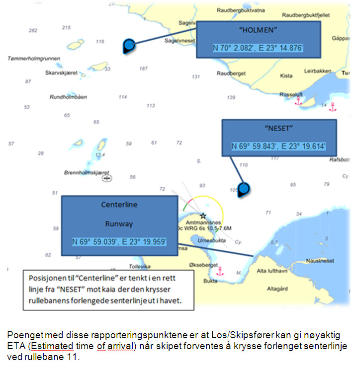
Radio calling-in points – Port of Alta - in the following positions: WGS84 DATUM.
Chart 96 - Vest-Finnmark, Altafjorden.
1) 70° 02.08' N, 23° 14.88' E
(2) 69° 59.84' N, 23° 19.61' E
Vessels planning to enter caution area close to Alta airport must report to the control tower on VHF channel 12 when passing the radio calling-in points. Applies for vessels higher than 12m.
På norsk:
Radio meldepunkter - Alta Havn på følgende posisjoner i sjøkartet: WGS84 DATUM
Kart 96 - Vest-Finnmark, Altafjorden
Meldepunkter for trafikkontroll etablert:
Fartøy som skal entre aktsomhetsområde ved Alta Lufthavn skal kontakte tårnet på VHF kanal 12 ved passering av meldepunktene. Gjelder for fartøy med høyde over 12m.
1) 70° 02.08' N, 23° 14.88' E
(2) 69° 59.84' N, 23° 19.61' E

Port-information
General Port information, Pilot info, Dock info and Anchorage information.
| Item | General Port information |
| Prevailing Weather | Winds: NW - N, 5 – 10 m/s |
| Currents: 1-3 knop W –E in the fjord | |
| Other: n/a | |
| Locations of pilot boarding areas | · Lodingen N 68,22,9 E 016,01,7 |
| · Fugloya N 70,06 E 020,13 | |
| · Honningsvaag N 70,57,5 E 025,58 | |
| · Harbour pilot also avail. | |
| Approach channel width & depth | No restrictions |
| Distance to dock/anchorage | 0,2 nm |
| Estimated time from pilot station to dock/anchorage at max. speed allowed by port authority | · Lodingen 19 hrs |
| · Fugloya 5 hrs | |
| · Honningsvaag 8 hrs | |
| Maximum LOA for Port | 265 M |
| Maximum allowed draft in port | The depth of harbour area is 45 m |
| Depth of channel and turning basin | 45 m – abt 500m |
| Air draft restrictions | Yes, See map above - Alta Airport |
| Current and tidal range | 2,46 m tidal difference |
| Depth alongside pier | 8 m llw |
| Turning basin diameter | 250 m |
| Air-draft restrictions | Yes |
| Tides & Currents. | AT THE QUAY 1 – 2 KNOP S – N,LY |
| Name/Draft/LOA of largest ship to call in port | So far , “Century” LOA 248 M – date 2008-08-01 |
| -- | |
| Item | Dock information |
| Names & Max Lengths of docks | 169 m Terminalkaia (ISPS) - NOALF 0002 |
| TYPE and Spacing of Fenders | Tires |
| Bollard Spacing | About 15 m in front and |
| Shore Gangways | No |
| Type and surface of dock | Asphalt |
| Preferred side of ship alongside | Starboard |
| Height of dock surface above MLW | 2,4 |
| Pier Obstructions | Steel |
| Tugs available | Can be ordered from Hammerfest with 48 hours notice. |
| Ship tenders allowed | YES |
| Item | Anchorage information |
| Secure Anchorage(s) Position (lat/Long) | Inner port area, exact position tba only on arrival |
| Min depth of Anchorage | 30 m |
| Type of Bottom | Sand |
| Wind Current | NW – N. |
| General Slope of Bottom | Sand |
| Distance to tender landing dock | 0,2 nm |
| Item | Other |
| Custom | Hammerfest Tollsted, ph: + 47 77 62 55 00, hammerfest.fartoy@toll.no |
| Airport | Alta Airport appr. 700 m from the quay |
| Port facility security | ISPS approved, guard 24 h when docked |
| Waste and water | Waste-handling an fresh water delivering |
| Transportation | Shuttle service, Excursion buses, Parking place for buses, Taxis, and Public transportation: YES |
Public information
- Tourist information: In city center, 4 km form pier.
- Bus: Modern sightseeing buses
- Taxi: Taxi and minibus available (+47 78435353) - App: "Taxifix" Alta Taxi
- VISA accepted
- Guide Service: Every major language Shopping: in the city center 4 km from pier
- Emergency: Alta Helsesenter, 4 km from pier Tax refund: No -
- Distances - Airport: 700 meters
- City Centre: 4 km.
- Terminal building for passenger: No
- Tourist information: Yes
- Tourist/ city maps: Yes
- Shopping: Sami souvenir at the pier
- Restrooms: No
- Local currency: NOK
- Currency exchange: In city


